The formation of the St. Joseph Downtown Community district was finalized on September 6, 2011. It is a special taxing district that is located in historic downtown St. Joseph, Missouri. Funding for the district is derived by a fifty cent per hundred dollars of valuation property tax and a half cent sales tax. Total tax revenue generated in the district is approximately $128,625 per year.
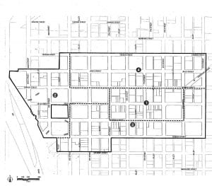 DISTRICT LEGAL DESCRIPTION
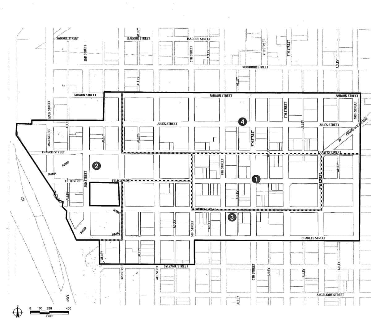
The following area descriptions are all located within Section 8, Township 57 North, Range 35 West, St. Joseph, Buchanan County, Missouri.
Beginning at the intersection of the North right-of-way line of Faraon Street and the East right-of-way line of Tenth Street, thence South along the East right-of-way line of Tenth Street to the South right-of-way line of Charles Street, thence West along said South right-of-way line to the East right-of-way line of Fifth Street, thence South along said East right-of-way line to the North right-of-way line of Sylvanie Street, thence West along said North right-of-way line to the West line of an alley in block 33 Original Town subdivision, thence North along said West line of alley to the South right-of-way line of Charles Street, thence West along said South right-of-way line to the Easterly right-of-way line of Interstate 229, thence Westerly and Northwesterly along the Easterly right-of-way line of Interstate 229 to the intersection with the South right-of-way line of Jules Street, thence East along said South right-of-way line to the Southerly extension of the centerline of a vacated alley in block 8 Original Town subdivision, thence North along said alley centerline to the North right-of-way line of Jules Street, thence East along said North right-of-way line to the centerline of an alley in block 28 Original Town subdivision, thence North along said alley centerline to the North right-of-way line of Faraon Street, thence East along said North right-of-way line to the East right-of-way line of Tenth Street and the Point of Beginning.
REDEVELOPMENT PROJECT AREA 1.
Beginning at the intersection of the centerlines of Fifth Street and Francis Street, thence East along the centerline of Francis Street to the intersection with the centerline of Ninth Street, thence South along said centerline to the intersection with the centerline of Edmond Street, thence West along said centerline to the intersection with the centerline of Fifth Street, thence North along said centerline to the intersection with the centerline of Francis Street and the Point of Beginning.
REDEVELOPMENT PROJECT AREA 2.
Beginning at the intersection of the centerlines of Fifth Street and Francis Street, thence South along the centerline of Fifth Street to the intersection with the centerline of Felix Street, thence West along said centerline to the intersection with the centerline of Third Street, thence South along said centerline to the intersection with the extended South right-of-way line of Charles Street, thence West along said South right-of-way line to the Easterly right-of-way line of Interstate 229, thence Westerly and Northwesterly along the Easterly right-of-way line of Interstate 229 to the intersection with the South right-of-way line of Jules Street, thence East along said South right-of-way line to the Southerly extension of the centerline of a vacated alley in block 8 Original Town subdivision, thence North along said alley centerline to the North right-of-way line of Jules Street, thence East along said North right-of-way line to the centerline of an alley in block 28 Original Town subdivision, thence North along said alley centerline to the North right-of-way line of Faraon Street, thence East along said North right-of-way line to the intersection with the centerline of Third Street, thence South along said centerline to the intersection with the centerline of Francis Street, thence East along said centerline to the intersection with the centerline of Fifth Street and the Point of beginning.
REDEVELOPMENT PROJECT AREA 3.
Beginning at the intersection of the centerlines of Felix Street and Fifth Street, thence South along the centerline of Fifth Street to the intersection with the centerline of Edmond Street, thence East along said centerline to the intersection with the centerline of Ninth Street, thence North along said centerline to the intersection with the centerline of Francis Street, thence East along said centerline to the extended East right-of-way line of Tenth Street, thence South along said East right-of-way line to the South right-of-way line of Charles Street, thence West along said South right-of-way line to the East right-of-way line of Fifth Street, thence South along said East right-of-way line to the North right-of-way line of Sylvanie Street, thence West along said North right-of-way line to the West line of an alley in Block 33 Original Town subdivision, thence North along said West line of alley to the South right-of-way line of Charles Street, thence East along said South right-of-way line to the intersection with the centerline of Third Street, thence North along said centerline to the intersection with the centerline of Felix Street, thence East along said centerline to the centerline of Fifth Street and the Point of Beginning.
REDEVELOPMENT PROJECT AREA 4.
Beginning at the intersection of the centerlines of Francis Street and Third Street, thence North along the centerline of Third Street to the extended North right-of-way line of Faraon Street, thence East along said North right-of-way line to the East right-of-way line of Tenth Street, thence South along said East right-of-way line to the centerline of Francis Street, thence West along said centerline to the centerline of Third Street and the Point of Beginning.
The mission of the St. Joseph Downtown Community Improvement District is to create and promote economic and cultural opportunities within the district by providing businesses and residents a means to fund new services and capital improvements.


